module LANDUSE More...
Functions/Subroutines | |
| subroutine, public | landuse_setup |
| Setup. More... | |
| subroutine, public | landuse_calc_fact |
| subroutine, public | landuse_write |
| Write landuse data. More... | |
Variables | |
| real(rp), dimension(:,:), allocatable, public | landuse_fact_ocean |
| ocean factor More... | |
| real(rp), dimension(:,:), allocatable, public | landuse_fact_land |
| land factor More... | |
| real(rp), dimension(:,:), allocatable, public | landuse_fact_urban |
| urban factor More... | |
| real(rp), dimension(:,:), allocatable, public | landuse_frac_land |
| land fraction More... | |
| real(rp), dimension(:,:), allocatable, public | landuse_frac_lake |
| lake fraction More... | |
| real(rp), dimension(:,:), allocatable, public | landuse_frac_urban |
| urban fraction More... | |
| integer, public | landuse_pft_mosaic = 2 |
| number of PFT mosaic More... | |
| integer, public | landuse_pft_nmax = 15 |
| number of plant functional type(PFT) More... | |
| real(rp), dimension(:,:,:), allocatable, public | landuse_frac_pft |
| fraction of PFT for each mosaic More... | |
| integer, dimension(:,:,:), allocatable, public | landuse_index_pft |
| index of PFT for each mosaic More... | |
Detailed Description
module LANDUSE
- Description
- Land use category module Manage land/lake/urban/PFT fraction and PFT index
- NAMELIST
-
PARAM_LANDUSE
name type default value comment LANDUSE_IN_BASENAME character(len=H_LONG) '' basename of the input file LANDUSE_IN_CHECK_COORDINATES logical .true. switch for check of coordinates LANDUSE_OUT_BASENAME character(len=H_LONG) '' basename of the output file LANDUSE_OUT_DTYPE character(len=H_SHORT) 'DEFAULT' REAL4 or REAL8 LANDUSE_PFT_MOSAIC integer 2 number of PFT mosaic LANDUSE_PFT_NMAX integer 15 number of plant functional type(PFT) LANDUSE_ALLOCEAN logical .false. LANDUSE_ALLLAND logical .false. LANDUSE_ALLURBAN logical .false. LANDUSE_MOSAICWORLD logical .false.
-
PARAM_LANDUSE
- History Output
- No history output
Function/Subroutine Documentation
◆ landuse_setup()
| subroutine, public scale_landuse::landuse_setup | ( | ) |
Setup.
Definition at line 74 of file scale_landuse.F90.
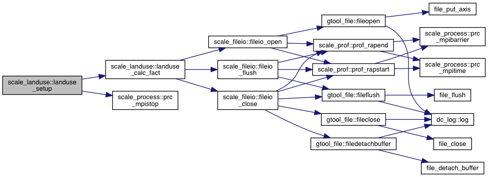
References scale_grid_index::ia, scale_stdio::io_fid_conf, scale_stdio::io_fid_log, scale_stdio::io_fid_nml, scale_stdio::io_l, scale_stdio::io_nml, scale_grid_index::ja, landuse_calc_fact(), landuse_fact_land, landuse_fact_ocean, landuse_fact_urban, landuse_frac_lake, landuse_frac_land, landuse_frac_pft, landuse_frac_urban, landuse_index_pft, landuse_pft_mosaic, landuse_pft_nmax, and scale_process::prc_mpistop().
Referenced by mod_rm_driver::scalerm(), and mod_rm_prep::scalerm_prep().


◆ landuse_calc_fact()
| subroutine, public scale_landuse::landuse_calc_fact | ( | ) |
Definition at line 156 of file scale_landuse.F90.
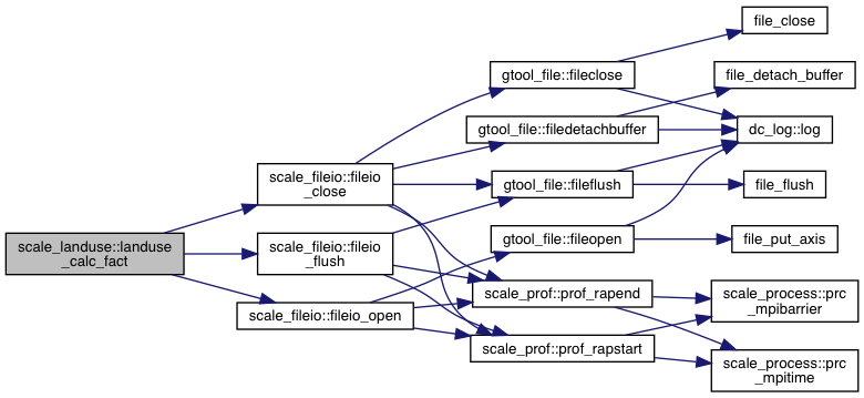
References scale_fileio::fileio_close(), scale_fileio::fileio_flush(), scale_fileio::fileio_open(), scale_stdio::io_fid_log, scale_stdio::io_l, landuse_fact_land, landuse_fact_ocean, landuse_fact_urban, landuse_frac_lake, landuse_frac_land, landuse_frac_pft, landuse_frac_urban, landuse_index_pft, and landuse_pft_mosaic.
Referenced by mod_cnvlanduse::cnvlanduse(), mod_mkinit::interporation_fact(), and landuse_setup().


◆ landuse_write()
| subroutine, public scale_landuse::landuse_write | ( | ) |
Write landuse data.
Definition at line 271 of file scale_landuse.F90.
References scale_fileio::fileio_close(), scale_fileio::fileio_create(), scale_fileio::fileio_def_var(), scale_fileio::fileio_enddef(), scale_stdio::io_fid_log, scale_stdio::io_l, landuse_fact_land, landuse_fact_ocean, landuse_fact_urban, landuse_frac_lake, landuse_frac_land, landuse_frac_pft, landuse_frac_urban, and landuse_pft_mosaic.
Referenced by mod_cnvlanduse::cnvlanduse(), and mod_mkinit::mkinit().


Variable Documentation
◆ landuse_fact_ocean
| real(rp), dimension(:,:), allocatable, public scale_landuse::landuse_fact_ocean |
ocean factor
Definition at line 35 of file scale_landuse.F90.
Referenced by mod_atmos_phy_rd_driver::atmos_phy_rd_driver(), mod_cpl_vars::cpl_getsfc_atm(), mod_cpl_vars::cpl_vars_setup(), landuse_calc_fact(), landuse_setup(), landuse_write(), scale_ocean_phy_file::ocean_phy_file_setup(), scale_ocean_phy_slab::ocean_phy_slab(), scale_ocean_sfc_const::ocean_sfc_const(), scale_ocean_sfc_slab::ocean_sfc_slab(), and mod_realinput::realinput_surface().
◆ landuse_fact_land
| real(rp), dimension (:,:), allocatable, public scale_landuse::landuse_fact_land |
land factor
Definition at line 36 of file scale_landuse.F90.
Referenced by mod_atmos_phy_rd_driver::atmos_phy_rd_driver(), mod_cpl_vars::cpl_getsfc_atm(), mod_cpl_vars::cpl_vars_setup(), scale_land_phy_slab::land_phy_slab(), scale_land_sfc_const::land_sfc_const(), scale_land_sfc_thick_slab::land_sfc_thick_slab(), scale_land_sfc_thin_slab::land_sfc_thin_slab(), landuse_calc_fact(), landuse_setup(), landuse_write(), and mod_realinput::realinput_surface().
◆ landuse_fact_urban
| real(rp), dimension(:,:), allocatable, public scale_landuse::landuse_fact_urban |
urban factor
Definition at line 37 of file scale_landuse.F90.
Referenced by mod_atmos_phy_rd_driver::atmos_phy_rd_driver(), mod_cpl_vars::cpl_getsfc_atm(), mod_cpl_vars::cpl_vars_setup(), landuse_calc_fact(), landuse_setup(), landuse_write(), mod_realinput::realinput_surface(), and scale_urban_phy_slc::urban_phy_slc_setup().
◆ landuse_frac_land
| real(rp), dimension (:,:), allocatable, public scale_landuse::landuse_frac_land |
land fraction
Definition at line 39 of file scale_landuse.F90.
Referenced by mod_cnvlanduse::cnvlanduse(), scale_history::hist_setup(), mod_mkinit::interporation_fact(), landuse_calc_fact(), landuse_setup(), landuse_write(), and mod_realinput::parentatomsetup().
◆ landuse_frac_lake
| real(rp), dimension (:,:), allocatable, public scale_landuse::landuse_frac_lake |
lake fraction
Definition at line 40 of file scale_landuse.F90.
Referenced by mod_cnvlanduse::cnvlanduse(), landuse_calc_fact(), landuse_setup(), and landuse_write().
◆ landuse_frac_urban
| real(rp), dimension(:,:), allocatable, public scale_landuse::landuse_frac_urban |
urban fraction
Definition at line 41 of file scale_landuse.F90.
Referenced by mod_cnvlanduse::cnvlanduse(), mod_mkinit::interporation_fact(), landuse_calc_fact(), landuse_setup(), and landuse_write().
◆ landuse_pft_mosaic
| integer, public scale_landuse::landuse_pft_mosaic = 2 |
number of PFT mosaic
Definition at line 43 of file scale_landuse.F90.
Referenced by mod_cnvlanduse::cnvlanduse(), landuse_calc_fact(), landuse_setup(), and landuse_write().
◆ landuse_pft_nmax
| integer, public scale_landuse::landuse_pft_nmax = 15 |
number of plant functional type(PFT)
Definition at line 44 of file scale_landuse.F90.
Referenced by mod_cnvlanduse::cnvlanduse(), mod_land_vars::land_vars_external_in(), mod_land_vars::land_vars_setup(), and landuse_setup().
◆ landuse_frac_pft
| real(rp), dimension (:,:,:), allocatable, public scale_landuse::landuse_frac_pft |
fraction of PFT for each mosaic
Definition at line 46 of file scale_landuse.F90.
Referenced by mod_cnvlanduse::cnvlanduse(), landuse_calc_fact(), landuse_setup(), and landuse_write().
◆ landuse_index_pft
| integer, dimension(:,:,:), allocatable, public scale_landuse::landuse_index_pft |
index of PFT for each mosaic
Definition at line 47 of file scale_landuse.F90.
Referenced by mod_cnvlanduse::cnvlanduse(), mod_land_vars::land_vars_setup(), landuse_calc_fact(), and landuse_setup().
 1.8.14