module file / history_cartesC More...
Functions/Subroutines | |
| subroutine, public | file_history_cartesc_setup |
| Setup. More... | |
| subroutine, public | file_history_cartesc_set_pres (PRES, PRESH, SFC_PRES) |
| set hydrostatic pressure for pressure coordinate More... | |
| subroutine | file_history_cartesc_truncate_1d (src, dim_type, zcoord, fill_halo, dst) |
| truncate 1D data to history buffer More... | |
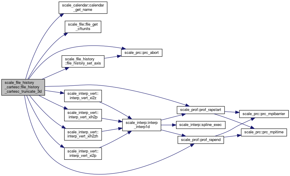
| subroutine | file_history_cartesc_truncate_3d (src, dim_type, zcoord, fill_halo, dst) |
| truncate 3D data to history buffer More... | |
Detailed Description
module file / history_cartesC
- Description
- History output module for the cartesianC grid
- NAMELIST
-
PARAM_FILE_HISTORY_CARTESC
name type default value comment FILE_HISTORY_CARTESC_MODEL_NLAYER integer -1 FILE_HISTORY_CARTESC_PRES_NLAYER integer 0 FILE_HISTORY_CARTESC_PRES real(RP), dimension(NLAYER_MAX) > pressure level to output [hPa] FILE_HISTORY_CARTESC_BOUNDARY logical .false.
-
PARAM_FILE_HISTORY_CARTESC
- History Output
- No history output
Function/Subroutine Documentation
◆ file_history_cartesc_setup()
| subroutine, public scale_file_history_cartesc::file_history_cartesc_setup |
Setup.
Definition at line 79 of file scale_file_history_cartesC.F90.
References scale_calendar::calendar_get_name(), file_history_cartesc_truncate_1d(), file_history_cartesc_truncate_3d(), scale_file_history::file_history_set_nowdate(), scale_file_history::file_history_setup(), scale_file_history::file_history_truncate_1d, scale_file_history::file_history_truncate_2d, scale_file_history::file_history_truncate_3d, scale_file_h::file_hshort, scale_io::h_institute, scale_io::h_source, scale_atmos_grid_cartesc_index::ia, scale_atmos_grid_cartesc_index::ie, scale_atmos_grid_cartesc_index::ieb, scale_atmos_grid_cartesc_index::imaxb, scale_interp_vert::interp_vert_alloc_pres(), scale_io::io_fid_conf, scale_atmos_grid_cartesc_index::is, scale_atmos_grid_cartesc_index::isb, scale_atmos_grid_cartesc_index::ja, scale_atmos_grid_cartesc_index::je, scale_atmos_grid_cartesc_index::jeb, scale_atmos_grid_cartesc_index::jmaxb, scale_atmos_grid_cartesc_index::js, scale_atmos_grid_cartesc_index::jsb, scale_atmos_grid_cartesc_index::ka, scale_atmos_grid_cartesc_index::kmax, scale_prc_cartesc::prc_has_s, scale_prc_cartesc::prc_has_w, scale_prc::prc_masterrank, scale_prc::prc_myrank, scale_prc_cartesc::prc_periodic_x, scale_prc_cartesc::prc_periodic_y, scale_prc_cartesc::prc_twod, scale_time::time_dtsec, scale_time::time_nowdate, scale_time::time_nowstep, scale_time::time_nowsubsec, and scale_time::time_startdaysec.
Referenced by mod_rm_driver::rm_driver().


◆ file_history_cartesc_set_pres()
| subroutine, public scale_file_history_cartesc::file_history_cartesc_set_pres | ( | real(rp), dimension (:,:,:), intent(in) | PRES, |
| real(rp), dimension (:,:,:), intent(in) | PRESH, | ||
| real(rp), dimension( :,:), intent(in) | SFC_PRES | ||
| ) |
set hydrostatic pressure for pressure coordinate
Definition at line 260 of file scale_file_history_cartesC.F90.
References scale_file_history::file_history_set_dim(), scale_atmos_grid_cartesc_index::ia, scale_atmos_grid_cartesc_index::ieb, scale_atmos_grid_cartesc_index::imax, scale_atmos_grid_cartesc_index::imaxb, scale_interp_vert::interp_vert_setcoef_pres(), scale_atmos_grid_cartesc_index::isb, scale_atmos_grid_cartesc_index::isgb, scale_atmos_grid_cartesc_index::ja, scale_atmos_grid_cartesc_index::jeb, scale_atmos_grid_cartesc_index::jmax, scale_atmos_grid_cartesc_index::jmaxb, scale_atmos_grid_cartesc_index::jsb, scale_atmos_grid_cartesc_index::jsgb, scale_atmos_grid_cartesc_index::ka, scale_atmos_grid_cartesc_index::ke, scale_atmos_grid_cartesc_index::ks, scale_land_grid_cartesc_index::lkmax, scale_mapprojection::mapprojection_mappinginfo, scale_ocean_grid_cartesc_index::okmax, scale_prc_cartesc::prc_2drank, scale_prc_cartesc::prc_has_s, scale_prc_cartesc::prc_has_w, scale_prc::prc_myrank, scale_prc_cartesc::prc_periodic_x, scale_prc_cartesc::prc_periodic_y, and scale_urban_grid_cartesc_index::ukmax.
Referenced by mod_atmos_vars::atmos_vars_history_setpres().


◆ file_history_cartesc_truncate_1d()
| subroutine scale_file_history_cartesc::file_history_cartesc_truncate_1d | ( | real(rp), dimension(:), intent(in) | src, |
| character(len=*), intent(in) | dim_type, | ||
| character(len=*), intent(in) | zcoord, | ||
| logical, intent(in) | fill_halo, | ||
| real(dp), dimension(:), intent(out) | dst | ||
| ) |
truncate 1D data to history buffer
Definition at line 493 of file scale_file_history_cartesC.F90.
References scale_file_h::file_rmiss, scale_atmos_grid_cartesc_index::ie, scale_atmos_grid_cartesc_index::is, scale_atmos_grid_cartesc_index::je, scale_atmos_grid_cartesc_index::js, scale_atmos_grid_cartesc_index::ks, scale_land_grid_cartesc_index::lkmax, scale_land_grid_cartesc_index::lks, scale_ocean_grid_cartesc_index::okmax, scale_ocean_grid_cartesc_index::oks, scale_prc::prc_abort(), scale_urban_grid_cartesc_index::ukmax, and scale_urban_grid_cartesc_index::uks.
Referenced by file_history_cartesc_setup().


◆ file_history_cartesc_truncate_3d()
| subroutine scale_file_history_cartesc::file_history_cartesc_truncate_3d | ( | real(rp), dimension(:,:,:), intent(in) | src, |
| character(len=*), intent(in) | dim_type, | ||
| character(len=*), intent(in) | zcoord, | ||
| logical, intent(in) | fill_halo, | ||
| real(dp), dimension(:), intent(out) | dst | ||
| ) |
truncate 3D data to history buffer
Definition at line 636 of file scale_file_history_cartesC.F90.
References scale_atmos_grid_cartesc::atmos_grid_cartesc_cbfx, scale_atmos_grid_cartesc::atmos_grid_cartesc_cbfxg, scale_atmos_grid_cartesc::atmos_grid_cartesc_cbfy, scale_atmos_grid_cartesc::atmos_grid_cartesc_cbfyg, scale_atmos_grid_cartesc::atmos_grid_cartesc_cbfz, scale_atmos_grid_cartesc::atmos_grid_cartesc_cdx, scale_atmos_grid_cartesc::atmos_grid_cartesc_cdxg, scale_atmos_grid_cartesc::atmos_grid_cartesc_cdy, scale_atmos_grid_cartesc::atmos_grid_cartesc_cdyg, scale_atmos_grid_cartesc::atmos_grid_cartesc_cdz, scale_atmos_grid_cartesc::atmos_grid_cartesc_cx, scale_atmos_grid_cartesc::atmos_grid_cartesc_cxg, scale_atmos_grid_cartesc::atmos_grid_cartesc_cy, scale_atmos_grid_cartesc::atmos_grid_cartesc_cyg, scale_atmos_grid_cartesc::atmos_grid_cartesc_cz, scale_atmos_grid_cartesc::atmos_grid_cartesc_fbfx, scale_atmos_grid_cartesc::atmos_grid_cartesc_fbfxg, scale_atmos_grid_cartesc::atmos_grid_cartesc_fbfy, scale_atmos_grid_cartesc::atmos_grid_cartesc_fbfyg, scale_atmos_grid_cartesc::atmos_grid_cartesc_fbfz, scale_atmos_grid_cartesc::atmos_grid_cartesc_fdx, scale_atmos_grid_cartesc::atmos_grid_cartesc_fdxg, scale_atmos_grid_cartesc::atmos_grid_cartesc_fdy, scale_atmos_grid_cartesc::atmos_grid_cartesc_fdyg, scale_atmos_grid_cartesc::atmos_grid_cartesc_fdz, scale_atmos_grid_cartesc::atmos_grid_cartesc_fx, scale_atmos_grid_cartesc::atmos_grid_cartesc_fxg, scale_atmos_grid_cartesc::atmos_grid_cartesc_fy, scale_atmos_grid_cartesc::atmos_grid_cartesc_fyg, scale_atmos_grid_cartesc::atmos_grid_cartesc_fz, scale_atmos_grid_cartesc::atmos_grid_cartesc_name, scale_atmos_grid_cartesc_real::atmos_grid_cartesc_real_area, scale_atmos_grid_cartesc_real::atmos_grid_cartesc_real_areauy, scale_atmos_grid_cartesc_real::atmos_grid_cartesc_real_areawuy_x, scale_atmos_grid_cartesc_real::atmos_grid_cartesc_real_areawxv_y, scale_atmos_grid_cartesc_real::atmos_grid_cartesc_real_areaxv, scale_atmos_grid_cartesc_real::atmos_grid_cartesc_real_areazuv_x, scale_atmos_grid_cartesc_real::atmos_grid_cartesc_real_areazuv_y, scale_atmos_grid_cartesc_real::atmos_grid_cartesc_real_areazuy_x, scale_atmos_grid_cartesc_real::atmos_grid_cartesc_real_areazxv_y, scale_atmos_grid_cartesc_real::atmos_grid_cartesc_real_areazxy_x, scale_atmos_grid_cartesc_real::atmos_grid_cartesc_real_areazxy_y, scale_atmos_grid_cartesc_real::atmos_grid_cartesc_real_cz, scale_atmos_grid_cartesc_real::atmos_grid_cartesc_real_fz, scale_atmos_grid_cartesc_real::atmos_grid_cartesc_real_lat, scale_atmos_grid_cartesc_real::atmos_grid_cartesc_real_latuv, scale_atmos_grid_cartesc_real::atmos_grid_cartesc_real_latuy, scale_atmos_grid_cartesc_real::atmos_grid_cartesc_real_latxv, scale_atmos_grid_cartesc_real::atmos_grid_cartesc_real_lon, scale_atmos_grid_cartesc_real::atmos_grid_cartesc_real_lonuv, scale_atmos_grid_cartesc_real::atmos_grid_cartesc_real_lonuy, scale_atmos_grid_cartesc_real::atmos_grid_cartesc_real_lonxv, scale_atmos_grid_cartesc_real::atmos_grid_cartesc_real_vol, scale_atmos_grid_cartesc_real::atmos_grid_cartesc_real_volwxy, scale_atmos_grid_cartesc_real::atmos_grid_cartesc_real_volzuy, scale_atmos_grid_cartesc_real::atmos_grid_cartesc_real_volzxv, scale_calendar::calendar_get_name(), scale_const::const_d2r, scale_const::const_undef, scale_file::file_get_cftunits(), scale_file_history::file_history_aggregate, scale_file_history::file_history_set_axis(), scale_file_h::file_rmiss, scale_atmos_grid_cartesc_index::iag, scale_atmos_grid_cartesc_index::iagb, scale_atmos_grid_cartesc_index::ie, scale_atmos_grid_cartesc_index::ie_ing, scale_atmos_grid_cartesc_index::ieb, scale_atmos_grid_cartesc_index::ihalo, scale_atmos_grid_cartesc_index::imax, scale_atmos_grid_cartesc_index::imaxg, scale_interp_vert::interp_available, scale_interp_vert::interp_vert_xi2p(), scale_interp_vert::interp_vert_xi2z(), scale_interp_vert::interp_vert_xih2p(), scale_interp_vert::interp_vert_xih2zh(), scale_atmos_grid_cartesc_index::is, scale_atmos_grid_cartesc_index::is_ing, scale_atmos_grid_cartesc_index::isb, scale_atmos_grid_cartesc_index::isga, scale_atmos_grid_cartesc_index::isgb, scale_atmos_grid_cartesc_index::jag, scale_atmos_grid_cartesc_index::jagb, scale_atmos_grid_cartesc_index::je, scale_atmos_grid_cartesc_index::je_ing, scale_atmos_grid_cartesc_index::jeb, scale_atmos_grid_cartesc_index::jhalo, scale_atmos_grid_cartesc_index::jmax, scale_atmos_grid_cartesc_index::jmaxg, scale_atmos_grid_cartesc_index::js, scale_atmos_grid_cartesc_index::js_ing, scale_atmos_grid_cartesc_index::jsb, scale_atmos_grid_cartesc_index::jsga, scale_atmos_grid_cartesc_index::jsgb, scale_atmos_grid_cartesc_index::ke, scale_atmos_grid_cartesc_index::khalo, scale_atmos_grid_cartesc_index::kmax, scale_atmos_grid_cartesc_index::ks, scale_land_grid_cartesc::land_grid_cartesc_cdz, scale_land_grid_cartesc::land_grid_cartesc_cz, scale_land_grid_cartesc::land_grid_cartesc_fz, scale_land_grid_cartesc_real::land_grid_cartesc_real_vol, scale_landuse::landuse_frac_land, scale_land_grid_cartesc_index::lke, scale_land_grid_cartesc_index::lkmax, scale_land_grid_cartesc_index::lks, scale_mapprojection::mapprojection_mappinginfo, scale_ocean_grid_cartesc::ocean_grid_cartesc_cdz, scale_ocean_grid_cartesc::ocean_grid_cartesc_cz, scale_ocean_grid_cartesc::ocean_grid_cartesc_fz, scale_ocean_grid_cartesc_real::ocean_grid_cartesc_real_vol, scale_ocean_grid_cartesc_index::oke, scale_ocean_grid_cartesc_index::okmax, scale_ocean_grid_cartesc_index::oks, scale_prc_cartesc::prc_2drank, scale_prc::prc_abort(), scale_prc_cartesc::prc_has_e, scale_prc_cartesc::prc_has_n, scale_prc_cartesc::prc_has_s, scale_prc_cartesc::prc_has_w, scale_prc::prc_myrank, scale_prc_cartesc::prc_num_x, scale_prc_cartesc::prc_num_y, scale_prc_cartesc::prc_periodic_x, scale_prc_cartesc::prc_periodic_y, scale_prc_cartesc::prc_twod, scale_prof::prof_rapend(), scale_prof::prof_rapstart(), scale_topography::topography_zsfc, scale_urban_grid_cartesc_index::uke, scale_urban_grid_cartesc_index::ukmax, scale_urban_grid_cartesc_index::uks, scale_urban_grid_cartesc::urban_grid_cartesc_cdz, scale_urban_grid_cartesc::urban_grid_cartesc_cz, scale_urban_grid_cartesc::urban_grid_cartesc_fz, and scale_urban_grid_cartesc_real::urban_grid_cartesc_real_vol.
Referenced by file_history_cartesc_setup().


 1.8.17